Waymo’s driverless cars are starting to do more than shuttle passengers around Phoenix and San Francisco. The company is now feeding pothole data from its robotaxi fleet into Waze, turning every ride into a rolling road inspection that can help cities spot and fix crumbling pavement faster. The experiment hints at a future where autonomous vehicles and navigation apps quietly map street damage in the background, long before residents file a complaint.
The pilot is still limited in scope, but it connects three powerful forces: high-resolution sensors, crowdsourced mapping, and city maintenance budgets that are stretched thin. If it scales, the same technology that powers driverless rides could also become an early warning system for failing infrastructure.
What happened
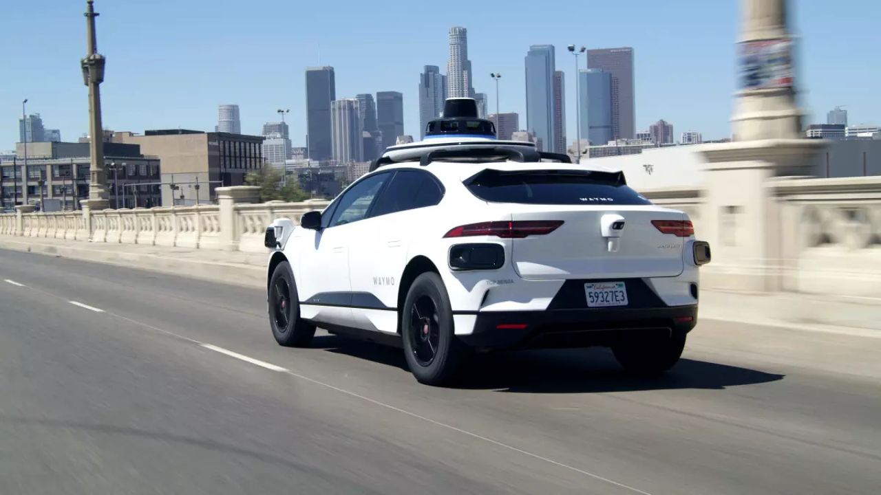
Waymo has begun using data from its self-driving Chrysler Pacifica minivans and Jaguar I-Pace vehicles to detect potholes on public roads, then sharing that information with Waze so the navigation app can mark rough patches for drivers and local agencies. The trial currently focuses on the company’s existing robotaxi service areas, which include parts of Phoenix and San Francisco, where its vehicles already log extensive daily mileage.
The system starts with the hardware already built into each robotaxi. Waymo’s vehicles use a mix of cameras, lidar, radar, and onboard accelerometers to understand the road surface in detail. When the car hits a sharp dip or bump, the sensors register the vertical movement and the software flags a potential pothole. The company then cross-checks that signal against the precise location of the vehicle and the surrounding road geometry to avoid confusing normal features like speed humps with actual damage.
Once a pothole candidate has been detected, the information is bundled into a structured report that includes location, approximate severity, and confidence level. These reports are then shared with Waze, which already supports user-submitted alerts for hazards such as debris, crashes, and police activity. Instead of relying on a human driver to tap a button when they notice a problem, the robotaxis can generate these alerts automatically and with meter-level precision, according to Waymo’s description of the project.
Waze incorporates the incoming data into its hazard layer, which can display warnings about potholes along a route. In some cases, the app can suggest small reroutes around heavily damaged segments, especially when multiple reports indicate that a stretch of road has deteriorated. The partnership effectively turns Waymo’s fleet into a continuous scanning tool for Waze, filling in gaps between sporadic human reports and one-off city inspections.
The pilot is not limited to a single municipality, although city agencies are a key audience. Waze already has a program that shares anonymized traffic and incident data with transportation departments. The new feed of robotaxi-detected potholes can slot into that channel so that public works teams receive a map of trouble spots, along with counts of how often they are encountered by vehicles using the app. That gives maintenance crews a fresh layer of evidence when deciding where to send limited repair teams.
Waymo’s approach builds on an emerging trend of using consumer technology to monitor road quality. Some cities have experimented with smartphone apps that use accelerometer data to infer pavement roughness. The robotaxi pilot takes that concept further by pairing much richer sensor data with a fleet that already drives the same streets repeatedly, which improves the reliability of the signals over time, as described in coverage of the.
For now, the project focuses on potholes, which are among the most visible and politically sensitive forms of road damage. The underlying detection pipeline could, in principle, be extended to other surface issues such as heaving, rutting, or missing manhole covers. Waymo has not publicly committed to those extensions, but the same sensor suite that spots a sharp depression can also capture more subtle changes in ride quality.
Why it matters
Potholes are more than a nuisance. They damage suspensions, bend wheels, and in some cases cause crashes when drivers swerve or brake suddenly. Repairing them is expensive for cities that manage thousands of lane-miles of asphalt, and the work is often reactive. Crews patch the worst complaints first, which can leave entire neighborhoods waiting. A steady stream of machine-detected data offers a different model, one where maintenance is guided by measured deterioration rather than scattered phone calls.
Waymo’s fleet gives cities something they have rarely had: frequent, objective measurements of the same road segments over days and weeks. A single human complaint might reflect a one-time impression or an outlier event. By contrast, if dozens of robotaxis register a sharp jolt at the same GPS coordinates, and the signal grows stronger over time, it suggests a pothole that is widening and deepening. Public works teams can use that pattern to prioritize repairs before the hole becomes large enough to cause serious damage.
The partnership also illustrates how autonomous vehicles can contribute to public infrastructure even for people who never ride in them. Every mile a robotaxi drives produces data about lane markings, traffic signals, and pavement quality. Until now, most of that information stayed inside the company’s mapping systems, used to refine the self-driving stack. By sharing a slice of it with Waze and, indirectly, with city agencies, Waymo is turning a private dataset into a public service.
From Waze’s perspective, automated pothole detection strengthens its core pitch of real-time, user-informed navigation. Human drivers are good at spotting unexpected obstacles, but they are inconsistent reporters. Some tap the screen to log an issue, others ignore it, and many hazards go unreported. Robotaxis never forget to file a report, and they can classify the severity of a pothole based on measured impact forces rather than subjective impressions. As one analysis of the project noted, the vehicles can flag road damage automatically without distracting human drivers.
There is also a safety dimension. Navigation apps already warn about accidents and stopped vehicles on the shoulder. Adding a reliable feed of pothole alerts can reduce sudden swerving and last-second lane changes, especially at night or in heavy rain when holes are hard to see. Over time, that could translate into fewer minor collisions and less wear on vehicles that depend on Waze for daily commuting.
For cities, the bigger prize is strategic planning. Traditional pavement management relies on periodic surveys, often conducted every few years, combined with visual inspections by staff. These methods are labor-intensive and miss the day-to-day evolution of road conditions. A continuous sensor-based feed changes the cadence. Engineers can watch how often a given segment triggers pothole alerts, compare that with traffic volume, and refine their resurfacing schedules accordingly. Streets that deteriorate faster than expected can be flagged for deeper reconstruction rather than repeated patching.
The cost implications are significant. Every emergency repair crew dispatched to fill a single large pothole consumes time, materials, and traffic control resources. If cities can identify clusters of emerging defects early, they can batch repairs into more efficient work orders. They can also target streets where repeated patches suggest underlying structural problems, which might justify a full mill-and-overlay project instead of endless quick fixes.
Privacy and data governance sit in the background of all this. Waymo’s pothole detection does not require video footage of pedestrians or license plates to be shared with Waze or city agencies. The relevant signal is the combination of vehicle motion and location, not the identities of nearby drivers. Still, residents and regulators will want assurances about how long such data is stored, how it is anonymized, and whether it could be repurposed for other forms of surveillance.
Equity is another concern. Waymo’s current service zones do not cover every neighborhood, and some lower-income areas may see fewer robotaxis on their streets. If pothole detection depends heavily on autonomous fleets, there is a risk that wealthier or more commercially attractive districts receive better data and faster repairs. Cities that use the feed will need to balance it against other sources, such as 311 complaints and manual inspections, to avoid reinforcing existing disparities in infrastructure quality.
The pilot hints at a broader shift in how transportation technology companies relate to public agencies. Instead of treating their data as a proprietary moat, firms like Waymo and Waze are experimenting with limited, targeted data-sharing arrangements that solve specific municipal problems. Potholes are a politically safe starting point. If the collaboration proves effective, it could open the door to similar feeds for faded lane markings, missing signage, or blocked bike lanes.
What to watch next
The immediate question is whether the pothole detection pilot expands beyond its initial zones and partners. Waymo’s robotaxis currently operate in defined service areas, and their coverage is densest along popular routes. For the system to deliver broad value, the company would need to either widen those zones or find ways to incorporate data from other fleets, such as delivery vans or personally owned vehicles equipped with compatible sensors.
Waze’s role will also evolve. The app has long relied on its community of drivers to validate and clear hazards, a process that helps filter out false reports. With automated inputs from robotaxis, Waze may need new mechanisms to handle conflicts between machine-generated alerts and human feedback. For example, if a pothole is filled but the automated system continues to flag a rough patch due to residual unevenness, human users might mark the report as outdated. How Waze reconciles those signals will shape the quality of its hazard maps.
City participation is another variable. Some transportation departments already integrate Waze data into their operations centers, using it to monitor congestion and incidents. Others are more cautious, either because of resource constraints or concerns about data accuracy. The success of the pothole initiative will depend on how many agencies choose to ingest the new feed and translate it into actionable work orders. Without that follow-through, even the best detection system will not lead to smoother roads.
Regulators are likely to pay attention as well. As autonomous vehicles take on more quasi-public functions, from mapping to incident detection, questions will arise about liability and standards. If a city relies on robotaxi data to prioritize repairs, and a missed pothole causes a serious crash, lawyers may ask whether the detection algorithms were sufficiently validated. That could push companies to publish more details about their methods, accuracy rates, and testing protocols.
There is room for technical improvement too. Current detection focuses on sharp, vertical jolts that correlate with classic potholes. Future iterations could blend that signal with image recognition, using camera feeds to classify the type and extent of damage. Over time, machine learning models could learn to distinguish between a shallow depression that can wait and a deep, tire-shredding cavity that demands immediate attention. They could also track the growth of individual defects, providing a kind of time-lapse view of pavement decay.
Competition may accelerate progress. Other automakers and mapping companies are experimenting with similar ideas, using connected vehicles to monitor road quality. If multiple fleets contribute data to shared platforms, cities could gain a much richer picture of their streets. The challenge will be standardization. Agencies do not want to juggle half a dozen incompatible formats and confidence scales. Industry groups and public bodies may eventually need to define common schemas for road-surface alerts.
More from Fast Lane Only